- Completed: 80%
- Client: B.G Hydro Investment Company Pvt.Ltd
- Location: Sindhupalchowk
- Duration: 1 Year
- Budget: Rs. 1
- 9851166725
- [email protected]
PROJECT DETAILS
Detailed Feasibility Study Balephi Khola Hydroelectric Project 40MW
- Description
- additional information
- reviews
-
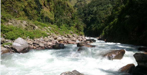
Balephi khola catchment lies within the Saptakoshi River Basin. The khola originates from Jugal Himal at an elevation of 6799m. Dorje Lakpa glacier and Jugal glacier are the major glaciers in the catchment. The catchment area at the proposed intake site of Balephi khola is 312 km2. Balephi khola catchment has an elevation ranging from 1600m to 6979m with average elevation of 4280m amsl at the proposed headworks site. The proposed intake is approximately 300m upstream and the powerhouse site is approximately 4.6km downstream from the confluence of Balephi khola and Nyasem khola. The catchment area at the proposed powerhouse site is 452km2
-
BKHEP does not have a permanent motorable access road at present. However a gravel road constructed by the downstream Upper Balephi-A HEP (36 MW) connects the powerhouse site of the project to the nearest road head Bolde. Bolde is located at a distance of about 35 km from Balephi Bazaar which is located on Araniko Highway. Balephi bazaar is located about 72 km from Kathmandu.
The developer has to construct about 5 km road from the existing under construction headwork site up to the proposed project’s headworks site. Then other 2 km road is to be constructed for access to the Surge shaft. So in total 7 km access road is to be constructed.
-
- BKHEP is a peaking type project with peaking time of 2 hours lying in the Jugal Rural Municipality of Sindhupalchowk district. The project lies about 126 km north-east of the capital and about 40 km north of the Kodari Rajmarga. Geographically the project lies between latitudes 27o57' 01" N and 27o58'59" N and longitudes 85o47’05" E and 85o48'01" E.