- Completed: 60%
- Client: Dar Khola Hydropower Pvt.Ltd
- Location: Myagdi
- Duration: 12 Months
- Budget: Rs. 1
- 9851166725
- [email protected]
PROJECT DETAILS
Detailed Feasibility Study,Detail Engineering Design and Preparation of Tender Document of Dar Khola Hydropower Project 6.5 MW
- Description
- additional information
- reviews
-
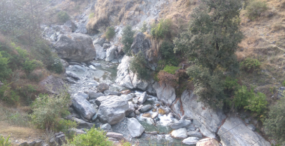
Dar Khola is a perennial rain fed river. It is one of the tributaries of Myagdi Khola which is one of the major tributaries of Kaligandaki River. The Kaligandaki River is one of the major rivers of the Narayani Basin. Dar Khola is located in Myagdi district, Dhaulagiri Zone, Western Development Region of Nepal.
The catchment of Dar Khola has not any glacier lake. Dar Khola after originating from an elevation of 4066 m flows in south-east direction and mixes with Myagdi Khola at an elevation of about 1300m. The proposed intake site at Dar Khola lies at an elevation of about 1867 m, whereas the proposed powerhouse site lies at right bank of Myagdi Khola just downstream from the confluence of Dar Khola with Myagdi Khola. As per Physiographical Region, 6.62% and 93.38% of the catchment at intake site of Dar Khola lay in High Himalayan and High Mountain Region respectively. More than one third of the catchment is covered by fairly dense mixed forest. The total catchment area contributing flow at intake site and at powerhouse site are 62.70 Km2 and 741.80 Km2 respectively.
-
- DKSHP is a run-of-the-river type project lying in the Dhaulagiri Rural Municipality of Myagdi district. Geographically the project lies between latitudes 28° 30' 00"N and 28° 30' 40"N and longitudes 83° 18' 47"E and 83° 20'20"E.